Overview of the Grace-Fo Satellite Mission
| ✅ Paper Type: Free Essay | ✅ Subject: Geography |
| ✅ Wordcount: 2822 words | ✅ Published: 04 Sep 2017 |
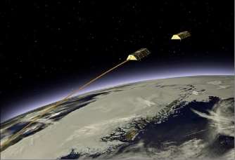
An artist depiction of the GRACE satellite configuration (Sharing, 2017)
The field of remote sensing is continuously expanding and adapting to yield new information about the earth and its complex systems. Modern satellite technology has expanded to be able to “monitor spatial and temporal variations in Earth’s global gravity field” (Schutze, 2016). The ability to monitor the Earth’s geoid now allows scientists to understand changes in hydrological characteristics on the surface of the planet including ice mass loss due to climate change and sea level rise (NASA JPL, 2017). The Gravity Recovery and Climate Experiment (GRACE) and its follow-on mission represent the application of this new technology that is essential for obtaining new data about global mass redistribution. The GRACE-FO mission will offer benefits due its use of active sensors and new technological inputs, but with any satellite system, there will be sources of error and challenges in design and data usage.
The first GRACE mission was launched in 2002 as a result of the combined efforts of the US National Aeronautics and Space Administration (NASA) and the Helmholtz Centre Potsdam – German Research Centre for Geosciences (GFZ) with assistance from partner institutions of both leading agencies (Schutze, 2016). The primary goal of the mission was to provide a new model of Earth’s gravity field every 30 days (Schlepp et al., 2015). Two identical satellites comprise the system with one trailing behind the other by 220km in a sun-synchronous orbit (Wahr, 2007). The satellites fly in a low polar orbit of 450 km and, the system circles the Earth every 90 minutes (Schutze, 2015). Spatial variations in Earth’s gravity field lead to different accelerations in the two satellites and therefore, differing inter-satellite separation (Schutze, 2016). Therefore, the GRACE mission is different than many other earth observation satellite missions because it does not make measurements of electromagnetic energy reflected back to it from Earth’s surface. The distance between the two satellites serves as the source of data. Also, uniquely, the satellites are left mostly without intervention to their orbit unless they separate by less than 170 km and more than 250 km (Sheard et al., 2012).
Fig 1. 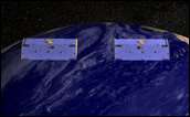
“Illustration of the positions of the two GRACE satellites in response to variations in Earth’s gravity field; a)The two satellites pass over the ocean and neither is affected; b)The lead spacecraft encounters a change in gravity over the more dense land mass and pulls away from the trailing spacecraft; c)The lead spacecraft moves back over water but now the trailing spacecraft changes position in response to the greater pull of gravity over the land mass” (Ward, 2003)
The first GRACE mission was only planned to run for 5 years, but far exceeded this as it is now in its 15th year of operation. The batteries in each satellite are fatiguing and accurate data is increasingly available in more irregular intervals (Görth et al., 2016). As a result, NASA and the GFZ created a follow-on mission to prevent data gaps (Schlepp et al., 2015). The follow-on was approved for launch in August 2017 and is known simply as the Gravity Recovery and Climate Experiment Follow-On (GRACE-FO) mission (Schlepp et al., 2015). The primary objective for this mission is the same as the previous; to create monthly global gravity models for five years (Sharing Earth Observation Resources, 2017).
The GRACE-FO mission will use some of the key sensor technology and overall design of the first GRACE mission, but will also include unique features. The same two-satellite design will remain but the inter-satellite distance will be reduced from 220 km to 50 km (Zheng and Xu, 2015). Several very important pieces of equipment will carry over from the first mission to each of the GRACE-FO satellites but will see improvements in design. This includes a microwave instrument (MWI) dependent on Global Positioning System (GPS) technology. The MWI system measures the distance between the satellites’ centers of mass and slight changes in distance represent gravitational changes (Tapley, 2008). A very sensitive accelerometer meant to measure the forces acting on the satellites besides gravity including atmospheric drag will also remain (Tapley, 2008). There were previous accelerometer errors and satellite-to-satellite measurement errors that will be reduced by the lower altitude and updates in design on the follow-on mission (Loomis, Nerem, and Luthcke, 2012).
The microwave ranging system employed can measure the distance between satellites to within one micron or about the diameter of one human blood cell (NASA JPL, 2017). It is known as a KBR system because it utilizes microwaves in the K (26 GHz) and Ka (32 GHz) frequency channels (Jiang et al., 2014). Distance measurements between the two satellites are taken by monitoring the time of “flight of microwave signals transmitted and received nearly simultaneously between the two spacecraft” (Bao et al., 2005). Previously collected data and models created by scientists based on known gravitational differences linked to mountains and ocean trenches, the location of the sun, and the flow of the tides are compared to new measurements of the satellites to interpret gravitational changes (NASA JPL, 2017). Also, the GPS unit on board is used in tandem with the MWI to be able to understand the gravity field below and can accurately assign capture time to data (Sheard et al., 2012).

The accelerometer can then measure non-gravitational forces affecting the satellite as previously mentioned including atmospheric drag and solar radiation pressure (Schutze, 2016). These additional forces are then subtracted from measurements taken by the MWI. At the low altitude of orbit of GRACE comes changing solar radiation and large thermal disturbances to on-board instruments (Schutze, 2016). As a result, one improvement to the accelerometer on the GRACE-FO satellites will be placing the measurement digitalization unit in a temperature controlled area of the spacecraft to prevent temperature variation that can make data inaccurate (Christophe et al., 2015).
The FO mission will include new technology known as a laser interferometer that will make measures that are at least 25 times more precise than the on-board microwave ranging system due to shorter wavelength usage (Sharing…, 2017). The LRI uses an “active transponder principle”, which means that the weak incoming received (RX) beam to the trailing satellite is replaced by a strong local oscillator (LO) beam. The LO beam is then reflected back to the lead satellite by a Triple Mirror Assembly (TMA) which directs the beam and influences the amount of light returned (Fledderman et al., 2014). It also serves to effectively route the incoming beam around other important hardware pieces (Fledderman et al., 2014).
The use of the new laser interferometer represents the first time an active laser ranging system will be operated between two spacecraft (NASA JPL, 2017). However, the microwave system will remain intact to ensure continuity of data from the first mission and the use of interferometer represents only a technology demonstration (Sharing…, 2017). While some studies found the LRI technology could greatly increase the accuracy of gravity data, others found that there would be only moderate improvements in the accuracy models (Flechtner et al., 2015). However, seeing the results of the two systems as they operate simultaneously will create meaningful data for the planning of future of gravity field missions.
The GRACE-1 mission allowed for new breakthroughs in the fields of hydrology, oceanography, glaciology, geophysics, and geodesy (Sharing…, 2017). Since gravity is determined by mass, the GRACE systems have the capability to show how mass is distributed around the planet (Sharing…, 2017). However, GRACE has and will continue to have no vertical resolution and can therefore, not distinguish between surface water, soil moisture, and ground water (Bolton and Thomas, 2015). Land surface models therefore allow for the disaggregation of Terrestrial Water Storage (TWS) data by separating these data into layers with known points of distinction (Bolton and Thomas, 2015). For example, in a study of the High Plains region of the US, the variability of snow and surface water were found to make insignificant contributions to TWS variability compared to groundwater and soil moisture changes (Ward, 2003). Therefore, removing moisture data known from previous studies of the region allowed scientists to subtract these figures from the GRACE gravitational measurements to understand changes in groundwater levels over time (Ward, 2003). Over time, improvements in GRACE data processing have allowed for the detection of changes in TWS within 1.5 cm accuracies for a wide range of spatial and seasonal scales (Jiang et al., 2014).
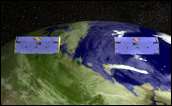
Fig 2. 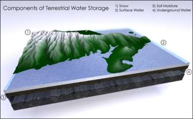
(Ward, 2003)
Measuring changes in global mass distribution can help scientists across many disciplines. GRACE data has also been used to observe increases and decreases in the ice and snow masses of glaciers and changes to the solid Earth following seismic activity such as the Fukushima earthquake of 2011 in Japan (Flechtner et al., 2016). Ocean water elevation changes caused by the devastating 2004 Sumatra tsunami had an impact of the inter-satellite distance of the GRACE satellites and showed how oceanic mass redistribution can affect Earth’s gravity field (Bao et al., 2005). Due to the relatively low spatial resolution of GRACE data, it is more useful for monitoring large-scale terrestrial water changes such as in past studies of the entire Amazon Basin or India (Bolton and Thomas, 2015). Other applications include flood and drought monitoring for management projects and interventions (Bolton and Thomas, 2015). For example, the US National Drought Mitigation Center uses GRACE data monthly to generate drought indicators and monitor surface water changes (NASA JPL, 2016). GRACE data also allows for the study of changes in deep ocean currents by measuring pressure changes at great depths. Similar pressure changes in the structure of the solid earth can be studied as well (NASA JPL, 2016).
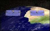
Fig 3. 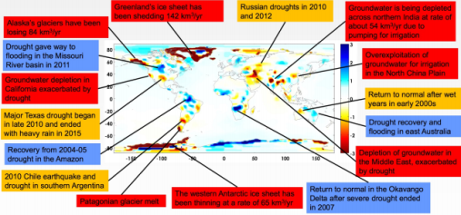
Trends in TWS and water mass redistribution made possible from GRACE data from 2002-2013
(Bolton and Thomas, 2015)
One of the benefits of an active satellite system such as the GRACE-1 and GRACE-FO compared to passive systems is that it can collect accurate data 24 hours per day because it creates its own source of electromagnetic energy (Schowengerdt, 2006). Also, the use of microwaves in the GRACE missions means that data is not affected by any type of cloud cover which often greatly affects accurate passive sensor data acquisition because the system only considers inter-satellite distance and GPS location for data retrieval.
Active sensors dependent on microwave signals like on the GRACE missions are unique in their capabilities. The launch of the first GRACE mission allowed for data on earth’s geoid that was 100 to 1000 times more accurate than previous models could estimate depending on the region of the global under consideration (Ward, 2003). GRACE data has also allowed scientists to under the impact of global climate change based on mass redistribution of water around the globe in a comprehensive and consistent manner never previously achieved. With more accurate data from the GRACE-FO mission and the security of continued data creation, changes caused by climate change will continue to be monitored and planning for issues such as drought can be improved.
However, compared to passive system data, the analysis of data is more complex and costly overall. The data output of the GRACE systems also requires a lot of manipulation and filtering to create meaningful datasets for a variety of disciplines. The microwave region of the electromagnetic spectrum is far from the visible region and therefore, the resulting data is also less intuitive for human interpretation (Schowengerdt, 2006). The raw data outputs for GRACE are just inter-satellite distance measurements and GPS data about satellite location (Ward, 2003).
Therefore, improvements in satellite technology components alone will not improve the data created by GRACE. Improvements also need to be made to the many geophysical models used in data processing (Loomis, Nerem, and Luthcke, 2012). For example, a complete global depiction of the earth’s gravity field is only available every 30 days while forces such as tidal shifts can change on a minute-to-minute basis. This difference creates an issue in which short-term differences are lost or their impact is underestimated (Sheard et al., 2012). Therefore, understanding gravitational influences not directly linked to mass balance changes is essential.
Fig 4. 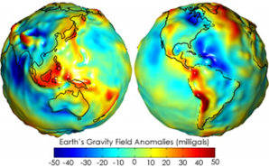
Models of gravity field anomalies on earth’s geoid created by comparing
GRACE data from two different temporal scales (Ward, 2003)
Models based on GRACE data are also limited by the noise present in the system data. This noise is linked to instrument errors, uncertainties in background models, and limitations in processing strategies (Siemes et al., 2013). In order to make meaningful measurements of mass changes on the earth using GRACE data, the noise of resulting models needs to be kept at a minimum, usually accomplished by applying filters (Siemes et al., 2013). However, when one problem is solved, another potentially arises. Filtering suppresses noise and blurs the signal, limiting the spatial resolution so much that part of the leak may affect nearby regions and cause errors in mass redistribution data (Siemes et al, 2013). However, more complex filtering methods have been developed to also minimize the blurring of data.
Also, the spatial resolution of GRACE data is ultimately limited (Siemes et al., 2013). The spatial range for very accurate GRACE data application was 400km to 40,000 km for the first mission (Tapley, 2008). The strength of GRACE data therefore lies in an ability to monitor mass changes over time rather than to understand the water storage in one area at a specific time. However, there is potential for the lower altitude of the GRACE-FO mission and the LRI technology utilization of shorter wavelengths to allow for higher spatial resolution.
The GRACE mission have shown that the use of active sensor technology on earth system satellite missions that utilizes microwave laser instruments and likely laser interferometers is incredibly efficient at understanding changes in earth’s geoid. With the launch of the GRACE-FO mission later this year, even more accurate measurements and greater understanding of mass redistribution of water around the planet will be possible. Despite the rapidly changing and unpredictable political climate of the United States government, the launch of the GRACE-FO mission seems undeterred and the collection of important data related to climate change-related issues will continue to be gathered.
References
- Bao, L.F., Piatanesi, A., Lu, Y., Hsu, H.T., and Zhou, X.H. (2005) Sumatra tsunami affects observations by GRACE satellites. Eos, Transactions American Geophysical Union, 86(39), 353-356.
- Bolton, J. and Thomas, B. (2015) Overview of the Gravity Recovery and Climate Experiment (GRACE) data and applications. NASA Applied Remote Sensing Training (ARSET). Powerpoint Presentation. http://www.cazalac.org/mwar_lac/fileadmin/imagenes2/Remote_Sensing/S5P1.pdf [2.3.17].
- Christophe, Boulanger, Foulon, Huynh, Lebat, Liorzou, and Perrot. (2015) A new generation of ultra-sensitive electrostatic accelerometers for GRACE Follow-on and towards the next generation gravity missions. Acta Astronautica, 117, 1-7.
- Flechtner, F., Neumayer, K., Dahle, C., Dobslaw, H., Fagiolini, E., Raimondo, J., and Güntner, A. (2016) What can be expected from the GRACE-FO laser ranging interferometer for earth science applications? Surveys in Geophysics, 37(2), 453-470. doi:10.1007/s10712-015-9338-y.
- Fleddermann, Ward, Elliot, Wuchenich, Gilles, Herding, . . . Shaddock. (2014) Testing the GRACE follow-on triple mirror assembly. Classical and Quantum Gravity, 31(19), 12.
- Görth, A., Sanjuan, J., Gohlke, M., Rasch, S., Abich, K., Braxmaier, C., and Heinzel, G. (2016) Test environments for the GRACE follow-on laser ranging interferometer. Journal of Physics: Conference Series, 716(1), 4.
- Jiang, D., Huang, Y., Fu, J., Wang, J., Ding, X., and Zhou, K. (2014) The review of GRACE data applications in terrestrial hydrology monitoring. Advances in Meteorology, 2014, Vol.2014.
- Loomis, Bryant D., Nerem, R. S., and Luthcke, S. B. (2012) Simulation study of a follow-on gravity mission to GRACE.(Report). Journal of Geodesy, 86(5), 319.
- NASA Jet Propulsion Laboratory (JPL). (2016). Applications – overview. NASA. GRACE Tellus: Gravity Recovery and Climate Experiment. https://grace.jpl.nasa.gov/applications/overview/ [2.3.17].
- —. (2017) GRACE-FO. NASA. GRACE Tellus: Gravity Recovery & Climate Experiment. https://grace.jpl.nasa.gov/mission/grace-fo/ [2.3.17].
- Schlepp B., Kirschner M., Sweetser T.H., Klipstein W.M., Dubovitsky S., (2015). Flight Dynamics Challenges for the GRACE Follow-On Mission. 25th International Symposium on Space Flight Dynamics (ISSFD). http://elib.dlr.de/98835/1/ISSFD2015_FD%20Challenges%20for-20GRACE-FO_Schlepp.pdf [2.3.17].
- Schowengerdt, R. (2006) Remote Sensing [electronic resource] : Models and Methods for Image Processing (3rd ed.). Burlington: Elsevier Science, 204-243.
- Schütze, D. (2016) Measuring Earth: Current status of the GRACE Follow-On Laser Ranging Interferometer. Journal of Physics: Conference Series, 716(1), 6.
- —. (2015) LISA technology sheds light on climate change: GRACE-FO mission. LISA Mission. Youtube. https://www.youtube.com/watch?v=tb29hD3OgFw [2.3.17].
- Sharing Earth Observation Resources. (2017) GRACE-FO (Gravity Recovery and Climate Experiment – Follow-On)/ GFO (GRACE Follow-On). EO Portal Directory. https://directory.eoportal.org/web/eoportal/satellite-missions/g/grace-fo [2.3.17].
- Sheard, B., Heinzel, S., Danzmann, G., Shaddock, K., Klipstein, D., and Folkner, A. (2012) Intersatellite laser ranging instrument for the GRACE follow-on mission. Journal of Geodesy, 86(12), 1083-1095.
- Siemes, C., Ditmar, P., Riva, R., Slobbe, E., Liu, M., and Farahani, D. (2013) Estimation of mass change trends in the Earth’s system on the basis of GRACE satellite data, with application to Greenland. Journal of Geodesy, 87(1), 69-87.
- Tapley, B. (2008) Gravity model determination from the GRACE mission. The Journal of the Astronautical Sciences, 56(3), 273-285.
- Wahr, J. (2007) Time Variable Gravity from Satellites-3.08. In Treatise on Geophysics, 218.
- Ward, A. (2003) Weighing earth’s water from space: challenges and limitations to using the GRACE technique. NASA Earth observatory. http://earthobservatory.nasa.gov/Features/WeighingWater/printall.php [7.3.17].
- Zheng Wei and Xu Houze. (2015) Progress in satellite gravity recovery from implemented CHAMP, GRACE and GOCE and future GRACE follow-on missions. Geodesy and Geodynamics, 6(4), 241-247. doi:10.1016/j.geog.2015.05.005
Cite This Work
To export a reference to this article please select a referencing stye below:
Related Services
View all


DMCA / Removal Request
If you are the original writer of this essay and no longer wish to have your work published on UKEssays.com then please click the following link to email our support team:
Request essay removal